

“Forced labor is difficult to find, but satellite imagery can really help identify where it’s happening in time for inspectors to intervene more effectively,” says Stanford scholar Victoria Ward. | iStock/Volodymyr Kalyniuk
Combining artificial intelligence with low-cost satellite imagery, researchers at Stanford’s Human Trafficking Data Lab have developed a system to spot forced labor at deforestation sites in Brazil’s Amazon rainforest.
Both legal and illegal deforestation efforts routinely rely on forced labor, and Brazilian prosecutors have been chasing down those abuses for years.
But the sites are remote and transitory, often abandoned before inspectors can reach them.
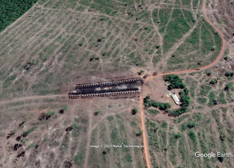
The new system addresses that challenge by recognizing one of the telltale signs of an active deforestation site: large arrays of charcoal ovens that convert the fallen timber into charcoal. The tent-shaped ovens are typically about three meters in diameter and usually arrayed in long rows.
“Forced labor is difficult to find, but satellite imagery can really help identify where it’s happening in time for inspectors to intervene more effectively,” says Victoria Ward, an assistant professor of pediatrics at Stanford Medicine. “The idea is to create transparency, so people can’t say they don’t know what’s happening.”
Ward and her colleagues, whose initial work was funded by a seed grant from the Stanford Institute for Human-Centered Artificial Intelligence and the Stanford King Center on Global Development, teamed up on the project with Brazilian labor prosecutors and nonprofit organizations.
The Stanford team began by collecting data from labor inspection reports at hundreds of charcoal-burning sites from 2018 to 2020. They then obtained satellite images for about 200 of those locations at the time of the inspections and hand-labeled their distinctive visual features.
That allowed them to create a large dataset for training AI image-recognition tools. By learning the visual cues of previous documented deforestation sites, the algorithm was able to pick out new sites from current satellite images, which are collected on an almost daily basis.
The satellite images come from Planet Labs, a San Francisco company that operates more than 150 tiny image-capturing satellites — most of them the size of a shoebox. The satellites orbit over most places on Earth almost daily, making it possible to monitor almost any location in real time. The company also maintains an archive of all those images, enabling analysts to track changes from day to day or year to year.
“The algorithms are cheap, and the satellites are running over this area all the time,” says Michael Baiocchi, an assistant professor of epidemiology at Stanford who worked on the project. “The algorithms can monitor this relentlessly.”
To sharpen their work, the Stanford team is hoping to contract with Planet Labs for selected high-resolution satellite images. That would enable them to acquire detailed evidence about areas that appear suspicious from low-resolution images.
But the broader idea is to develop an integrated tool that would automatically alert investigators in Brazil. Though the Stanford team is supplying the image analysis right now, the researchers hope that local authorities could eventually use it on their own.
Developing an initial algorithm based on patterns that investigators on the ground have identified is only a first step, however.
“We’re pretty sure the people behind these trafficking sites will adapt to our technique,” says Baiocchi. “We have to keep searching for new patterns that law enforcement doesn’t yet know. There are cutting- edge algorithms that can be designed to search for new, previously unknown patterns that humans haven't noticed. One of our goals is to put these new search algorithms in place to help find other ways that trafficking can be disrupted.”
Down the road, adds Ward, it might be possible to quantify broader patterns in forced labor, including its links to supply chains in agriculture and beef production.
The team is also working with its Brazilian partners including the Federal Labor Prosecution Office on developing a system that automates the process and helps investigators and rescuers mobilize more rapidly.
“Sometimes we are only limited by our own imaginations about where the technology can go,” says Kimberly Babiarz, a research scholar at Stanford who carried out much of the work. “Anything we can do to make life easier for the investigators as well as for the survivors is a win.”
Stanford HAI’s mission is to advance AI research, education, policy and practice to improve the human condition. Learn more.